
Seven radiocarbon determinations can be correlated with the above sequence, including those from non-cultural levels. They are the first dates for this region with which to reconstruct environmental conditions before the onset of settlement. At Lohoma Lal Tibba, three are from a test trench and one from a pyrotechnical feature on the south mound and a carbon deposit on the north mound. With the exception of one determination (142267, see below for a list of radiocarbon dates), collected from slumped, reworked burnt charcoal from the south mound test trench, these dates are highly consistent and form a tight cluster in the Harappan phase. Two dates from profiles at Chak Purbane Syal in the upper levels of its west and east mounds are consistent with the artifact materials and Late Harappan ceramics associated with them.
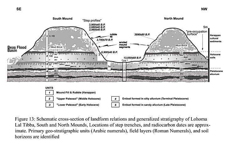
Other radiocarbon assessments listed on Table 2 from Lohoma Lal Tibba and Harappa are from non-cultural levels and provide the first dates for this region with which to reconstruct environmental conditions before the onset of settlement. One is from the south mound test trench, Figure 13, from an Early-Middle Holocene Lower Paleosol dated to 6900 +/- 40 BP. A second determination is from a 3 m deep core probing the substrate at the toe slope of the mound from the buried alluvium beneath the lower Paleosol. A date of 13,050 +/- 60 BP represents the terminal Pleistocene soil, followed by a protracted period of weathering that correlates with the hypothesized period of climatic optimization across South Asia. Atop these natural deposits are occupational levels preserved in mud-brick sediments and other cultural materials. Effectively 7,000 years of stable, probably warm and moist, environments are bracketed in the sequence. An additional radiocarbon determination from a cored sample extracted downstream (at crossing 6) from Lohoma Lal Tibba and Chak Purbane Syal represents a terminal Pleistocene terrace along the Beas; it is currently 3-4 m above the floodplain and yielded organic materials indicative of an ancient pond or swamp. The determination of 15, 720 +- 70 BP is consistent with higher Pleistocene-aged terraces of the river that have been documented upstream. These data provide the first dated evidence of a major interval of Beas valley downcutting subsequent to 15,500 BP.
Two cycles span the end of the Pleistocene and the present, with the key date of 13,050 +/- 60 B.P., perhaps signifying the terminal Pleistocene soil. A protracted period of weathering (maked by the “Bwk horizons”) correlates with the known period of climatic optimization across South Asia during the Early Holocene. Atop this sequence (“Upper A horizon”) is the base of the mound, dated to 3990 +/- 60 B.P., calibrated intercept date of 2480 B.C. This determination is in accord with the cultural materials preserved in the lower-mud-brick sediment near the base of the mound. Effectively 10,000 years of warm and moist environments are bracketed in the sequence.
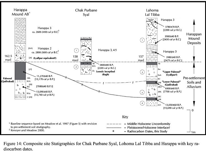
Figure 14 shows the composite site stratigraphies for Chak Purbane Syal, Lohoma Lal Tibba and Harappa. The site sequences are indexed by key radiocarbon dates. The section underscores the significance of the Early and Middle Holocene that marks the passage from the earliest cultural to terminal natural sequences at each site. Key soil, alluvial, and occupational stratigraphic breaks are shown, together with dates obtained for sediments and/or cultural features. In the case of Harappa, dates for individual cultural periods are averaged from published determinations and the column is taken from AB Mound, HARP Trench 42 (Meadow, Kenoyer, and Wright (1997). Only the lowermost 2 meters of cultural deposits at Harappa are illustrated. The figure places the age of the soil at the interface of the earliest occupation (Early Harappan) and terminal alluviation (11,300 – 13,100 BP, 13,200 - 15,800 cal BP). The soil is typically preserved on the margins of the landform.